Proof Of Magnetic Pole Shift (Reversal)
February 19, 2012, Submitted by: Ken Tweet
Image credit: NOAA National Geophysical Data Center
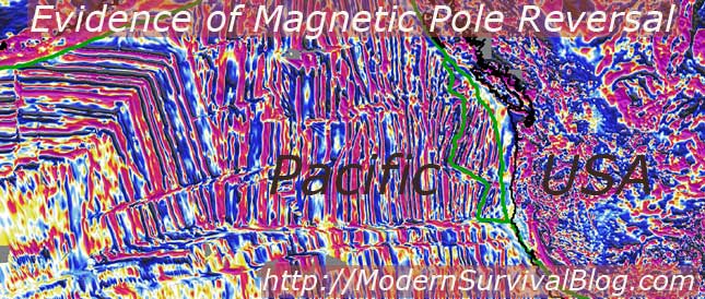
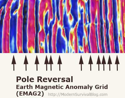
Pole Reversal evidence is clearly shown in NOAA’s new data from the National Geophysical Data Center, named “EMAG2″ Earth Magnetic Anomaly Grid (2-arc-minute resolution).
The map colors represent the direction of magnetism of the crustal surface rock (0 – 30 miles deep) as compared to the direction of magnetism of the earth’s core field deep below. The largest portion of the Earth’s magnetic field is generated in the Earth’s core, while magnetized rocks in the crust and upper mantle also make a significant contribution.
This map tells it all.
The way it works is…
New crust forms about 1 inch per year in many places, and during this process and as magnetic minerals cool below 1,100 degrees F, they develop a magnetic field and direction the same as the the strong core field beneath. This is ‘pretty cool’ because we can then ‘see’ the various fields and their magnetic ‘directions’ by way of data-mapping the magnetic fields of the surface crust and upper mantle.
Here’s how to interpret the colors on the map…
The red-to-purple areas indicate magnetic fields of the surface to be in the same direction as the core field, creating a ‘positive anomaly’. The blue-to-black areas indicate where the magnetic fields on the surface oppose the core field, resulting in a ‘negative anomaly’.
Yellow, white and light-blue indicate areas in which the surface field is either very weak, or is in the same direction as the (stronger) core field.
Pacific Ocean west of California

What to look for…
On the ocean floor ridges you can clearly see stripes of uniformly magnetized crust on each side of a ridge. Every few hundred thousand years the core field reverses direction, and the next set of stripes therefore acquires the opposite direction of magnetization. This is clearly visible in EMAG2 as striped patterns which are symmetric about the ridges and appear as opposing colors of red-purple to blue-black.
Wikipedia:
The cataclysmic pole shift hypothesis suggests that there have been geologically rapid shifts in the relative positions of the modern-day geographic locations of the poles and the axis of rotation of the Earth, creating calamities such as floods and tectonic events. Between approximately 790 and 810 million years ago, when the supercontinent Rodinia existed, two geologically-rapid phases of true polar wander may have occurred. In each of these, the Earth rotated ~55°
Are we overdue for a magnetic pole shift? Many say yes.
Do we know how quickly the pole shift will occur? No we do not. Many believe it is a very slow process, while others believe it to be much quicker.
Do we know the consequences of a magnetic pole shift? There is (are) the obvious issues with navigation methods that may still use magnetic compass. Many believe that earth stresses will occur resulting in dramatic earthquake and volcanic activity and some believe that during a magnetic shift that the surface of the earth will be highly vulnerable to solar radiation which is typically kept in check from the earth’s magnetic field.
Be Prepared. If you enjoyed this, or topics of current events risk awareness and survival preparedness, click here to check out our current homepage articles…


I’ve been following this story for over a year and learned that the northern magnetic field is moving toward Siberia at about 55 miles a year. The initial shift just about two years ago probably triggered the destructive Japan quake and tsunami. The earth’s core has an influence on the ocean water temperature which can mean changing weather patterns. It is theorized that the eastward movement of the northern magnetic field is drawing warmer than normal air to the northeast this winter and has affected the precipitation levels as well.
I wrote an article on this awhile ago, showing the increased rate of magnetic north pole movement. Rapid Pole Shift
My background consists of being a former weather map plotter in the US Navy. Since leaving the Navy, I keep myself educated on the weather. It’s an interesting inexact science. The movement of the magnetic field could be the beginning of what is said in the Holy Bible. If you are a reader than you understand.
Its true rev 6-12 to 6-17
Thanks Ken, I’m sharing this in my groups and Global Rumblings blog. Keep up the good work!
I say you start getting large earthquakes around magnetic south and magnetic north which of course are hundreds of miles away the north and south pole, then look out. There have been many earthquakes towrds the south polar regions the past few months, but nothing larger than 6 and 1/2 in magnitude. The closer earthquake to magnetic south I think was 5.6. You start to get 7′s in the south and north polar regions, YIKES.
If there ever was a rapid crustal shift of say several miles a day or more, then as I understand it the only safe location would be what are called pivot (axis) points. A pivot point is much like the lack of rotation that occurs at the south and north pole. I believe at the equator the planet rotates about 1000 mph and the further you get away from the equator the slower it gets towards a snail’s pace at the poles. If the crust were to shift you would want to be close to a pivot point as possible. Where this would be, who knows.
The faster the crusts shifts the more sloshing back and forth of the oceans and other water bodies there would be. Naturally you want to be as far inland as possible and up in altitude to avoid tsunamis. Unless the continent you are sitting on sinks, the way all continents were swamped like in the 2012 movie is not going to happen. Land has tremendous drag on water, and probably anywhere 500 miles away from coastlines will remain dry. The planet is 70% water, if it was 90% water then maybe all dry areas could get flooded, not with 30% land. Not all the water from an ocean basis is going to be forced up on to land, maybe the top 25% at the most. Low lying areas would be in deep trouble, but several hundred miles inland just will not be in danger. Just look at tsunamis and storm surges from mega hurricanes, seldom do they go more than a few miles inland because of land drag on the water.
Earthquakes and volcanoes are of course a threat, but really the one threat that seldom many people give much thought to are atmospheric storms. The one scenario not play in the 2012 movie was the severe magnetic storms that would have knocked any plane right out of the air. All depending on the speed of the shift you could have some storms that are more intense than EF-5 tornadoes all over the place. The weather is probably the one problem that will destroy as much or more so than the other natural calamities associate with a rapid crustal shift.
A slower crustal shift will also cause problems from climatic changes. If you are at say 45 degrees in latitude and move to 55 degrees over a few years your weather is going to be much more severe. IF Antarctica was to move away from the poles and become tropical you are going to have worldwide flooding from ice caps melting and again strange climatic changes. This is true even if it takes 10 years or more to move.
There are all sorts of problems with any crustal shift, no matter how fast. A simple magnetic pole shift on the other hand will probably just mean that it will be much more difficult to grow food because of the weakening of the magnetic field that protects the planet from cosmic radiation. Roots crops would be okay, but other plants could be in trouble from this. A simple magnetic polar shift without the crust moving would be the food supply being affected. I imagine the climate would also be affected in less immediately observable ways.
Something to watch, that is for sure. Something to worry about, not sure. Right now I would be more concerned with nuclear confrontations with Iran and Russia and China in the Middle East. I would be real concerned each new moon each month for the start of war there. Polar problems I would look for earthquake and volcanic activity getting real active in Antarctica and or the Arctic regions. Check the USGS each day and watch for earthquakes south of 60 degrees south, and north of 70 degrees north as an indication of something going on up and down there.
“Check the USGS each day and watch for earthquakes . . . north of 70 degrees north as an indication of something going on up and down there.”
Three days later of your post. . .
Earthquake Details
Date-Time Tuesday, February 21, 2012 at 13:50:43 UTC
Tuesday, February 21, 2012 at 04:50:43 AM at epicenter
Location 67.588°N, 166.680°W
Region BERING STRAIT
@ mddwave. I especially look at the Svalbard area because it is so close to the true magnetic north. It seems like when you have a 5+ up there that there is always an earthquake in the 6.5 or more soon to follow. I look at the Balleny Islands towards the Antarctica as a place to watch because it is close to South Magnetic Pole. There has really been a lot of action down towards Antarctica the past few months. If Antarctica starts getting large earthquakes and or increased volcanic action, then I would say LOOK OUT!
Have been trying to figure out earthquake precursors all my life because of living in earthquake zones. I feel that large earthquakes focus their built up tension away from the actual break and by looking at these far away foreshocks you can kind of get an idea where the next earthquake is going to strike and the size. The further these distant foreshocks are the larger the quake will be. I really thought that the Fox Islands was going to get a 6.4-6.8, but instead just a bunch of 5′s.
The past earthquakes of the last 3 weeks points to the area between the very northern part of Japan or the Kuril Islands to the very northern part of Vancouver Island or southern most tip of Alaska as the area that seems to be ready to break. I am surprised at how there has not been an earthquake there yet. The Kamchatka Peninsula is lighting up like a big red bullseye for the next quake from what I have been observing. I try to see a more three dimensional look of worldwide earthquake by sticking little stickers of each earthquake over 4.5 on a globe to see where the energy is being directed, rather than looking at the earthquake activity on a flat screen. Then after a 7+ I take off all the stickers and start the cycle all over again. It is so fascinating to see where the earthquakes occur on a globe that has that three dimensions to it. Like predicting past weather patterns that the Farmer’s Alamanac does each year to forecast the winter and summer weather, I truly believe that earthquakes also have patterns that can be predicted, getting the correct formula for doing so is what is so extremely difficult.