Wind Chill Frostbite Chart – Quick Guide Risk Assessment Temperatures

Based on NWS Wind Chill frostbite chart data and ‘Defence R&D Canada – Toronto’, a quick temperature assessment guide to your personal risk:
Wind Chill Frostbite Hazard
Wind Chill Temperature versus Time to Frostbite:
(temperatures in degrees-F)
32 to 16 (Low Risk)
14 to -17 (Moderate Risk)
-18 to -38 (High Risk) 10 to 30 minutes
-40 to -52 (Very High Risk) 5 to 10 minutes
-54 to -65 (Severe Risk) 2 to 5 minutes
-67 and colder (Extreme Risk) less than 2 minutes
Note that time to frostbite increases more quickly when wind chill temperatures fall below -17.
Frostbite Chart
The wind chill chart shown below is a temperature index which accurately indicates how cold the air feels on human skin.
The wind chill chart also includes a frostbite indicator. This reveals the temperatures at which wind speed coupled with skin exposure time will produce frostbite.
How To Use
To find the wind chill and time to frostbite:
Intersect or cross reference the top horizontal line (air temperature) with the wind speed along the left side vertical axis.
To find frostbite time, compare the cross referenced wind chill temperature with the color shade. The shaded colors represent a range of time to frostbite:
0 – 5 minutes (PURPLE)
5 – 10 minutes (dark blue)
10 – 30 minutes (blue)
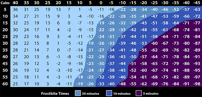
For example, using the wind chill chart,
An air temperature of 0°F with a wind speed of 15 mph will produce a wind chill temperature of -19°F. Under these conditions, exposed skin will freeze solid ( frostbite ) in approximately 30 minutes!
Lets say you’re snowmobiling (skiing?) in an air temperature of 0°F (not very comfortable!) and you’re traveling 30 mph. That’s -26 wind chill. Any exposed skin will freeze solid in about 15 minutes.
You’re a ‘diehard’ ice fisherman and out on a frozen lake with air temperatures hovering between 5°F and 0°F. The wind isn’t terribly strong, but steady across the lake at about 10-15mph. Guess what… you’re skin might freeze with frostbite in about 30 minutes…
Download and print your own full-size wind chill frostbite chart:
>> HotHands Hand Warmers
(view on amzn)
What is Wind Chill Temperature?
It’s the “feels like” temperature. It’s based on the rate of heat loss from exposed skin caused by the effects of wind and cold. As the wind increases, the body is cooled at a faster rate causing the skin temperature to drop.
Wind chill does not impact objects that are ‘not alive’ like car radiators and exposed water pipes, because these objects cannot cool below the actual air temperature.
What is Frostbite?
Frostbite is an injury to the body caused by freezing body tissue. The most susceptible parts of the body are the extremities such as fingers, toes, ear lobes, or the tip of the nose.
Symptoms include a loss of feeling in the extremity and a white or pale appearance. Medical attention is needed immediately for frostbite. The area should be SLOWLY re-warmed.
Cold Weather Tips
Hand and Foot Warmers
From experience I can tell you that these hand and toe warmers work very well! I always keep a box of each. When activated they stay warm for about 6 – 8 hours!
Best Selling Hand Warmers
Toe Warmers
(view on amzn)
Avoid Cotton
As the adage goes, “cotton kills.” Like a cotton towel soaks up water, cotton clothes will hold onto water for a long time. If they get wet, they stay wet. Nylon, synthetics, silk, and wool are the way to go.
Layers
Wear layers of loose fitting warm clothing. Trapped air between layers provides insulation.
Outerwear
Outer garments should be tightly woven, water repellent, and hooded.
Face, Eyes, Head
Goggles to protect your eyes and part of face. Wear a hat! Apparently 40% of your body heat can be lost from your head. Wear a face mask to cover your mouth, nose, and protect your lungs.
Hands
[ Read: Best Gloves With Thinsulate Insulation ]
Clean Clothes
Keep your clothing clean. Dirty clothes clog the insulating properties.
Sweating
Avoid overheating. When you sweat you loose heat faster.
Keep Active
Generate body heat without overheating (sweating).
Keep dry
Water, sweat, dampness will pull the heat from your body.
[ Read: The Warmest Survival Blanket – Wool Or Polar Fleece? ]
What is Hypothermia?
Hypothermia is abnormally low body temperature (below 95 degrees Fahrenheit). Warning signs include uncontrollable shivering, memory loss, disorientation, incoherence, slurred speech, drowsiness, and apparent exhaustion. Medical attention is needed immediately. If it is not available, begin warming the body SLOWLY.
[ Read: How To Prevent Frostbite, Hypothermia ]
