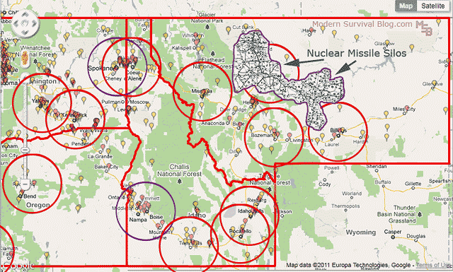
Northwest Survival Retreat Ideal Population Map
Click here for full resolution map
I put together this map awhile ago which illustrates perimeter regions surrounding population centers in the northwest.
City regions containing populations of 50,000 (red circles) and those with 200,000 (blue circles) in the states of Montana, Idaho, eastern Washington, and eastern Oregon.
The purpose of building the map was to discover the perimeter regions of cities with populations of 50,000 people – the perimeter being 50 miles out from the city region.
This perimeter is such that while living in a rural area (on the 50-mile perimeter), an approximate 1 hour drive would bring you into the ‘small’ city region for professional services or supplies.
It seemed to me that one possibility of an ideal full-time retreat location may exist along such a perimeter boundary. A boundary that does not overlap with another while still having somewhat reasonable access to services beyond the local area.
It was an interesting exercise (and time consuming to research and build the map). But I plan to do the same for other states in the country as well. (I like maps)
There are two perimeters on the map which you may want to stay away from if you are concerned about higher population centers (Boise and Spokane).
You may also want to stay away from the highlighted area of nuclear missile silos in Montana, particularly ‘down wind’ (e.g. Billings).
Montana Road and Recreation Atlas
Idaho Road and Recreation Atlas

