
Map Basics – How to Read Latitude and Longitude
Latitude and Longitude. They’re at the core of map reading. Latitude and Longitude are imaginary lines which lay on the surface of the earth to form a matrix of coordinates. However, the question is, how to read it? Which one is which?
Here is a basic explanation, and an easy way to remember which is which… and, a recommendation for a top-of-the-line compass for map reading.
How to Read LATITUDE
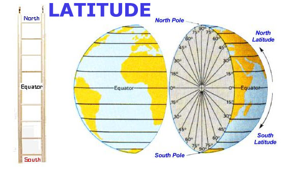
Image globes: geographyworldonline.com
Latitude lines are imaginary lines on the earth’s surface. Each line runs east and west around the globe. And each one represents a distance/location north or south of the Equator.
Lines of Latitude run parallel to the equator (east-west).
Remember LATITUDE by thinking of a LADDER (sounds similar). The rungs (steps) of a ladder going east-west…
The ladder has rungs which you climb to go up and down, similar to the lines of Latitude which go up and down across the circumference of the globe.
Latitude lines run east and west, but they tell you (they indicate locations on a map) how far up (North) or how far down (South).
The equator is Zero degrees. The poles are 90 degrees.
How to Read LONGITUDE
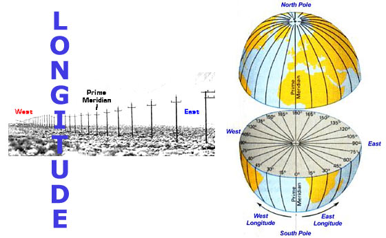
Image globes: geographyworldonline.com
Lines of Longitude run from pole to pole (north-south). They tell you the distance east or west from the ‘Prime Meridian’.
The Prime Meridian is Longitude Zero. It is a reference line from which longitude east and west are measured. It passes through Greenwich, England, the site of the Royal Greenwich Observatory (0 degrees).
Remember LONGITUDE by thinking of long, tall telephone poles (because Longitude lines run from pole to pole).
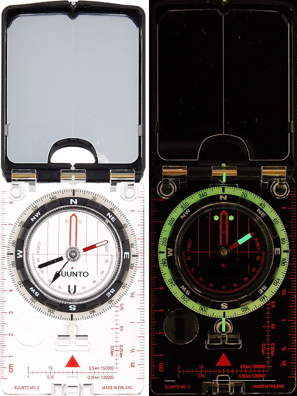
A top-of-the-line compass for map reading (with USGS MTM scales)
SUUNTO MC-2 Compass for Professionals and Hikers
(SUUNTO storefront on amzn)
Latitude – Longitude Grid
Lines of Latitude and Longitude come together to form a matrix, or grid.
Latitude and Longitude is a common grid system used for navigation. It will allow you to pinpoint your location with a high degree of accuracy.
Latitude is angular distance measured north and south of the Equator.
The Equator is 0 degrees.
As you go north of the equator, the Latitude increases all the way up to 90 degrees at the north pole.
If you go south of the equator, the Latitude increases all the way up to 90 degrees at the south pole.
In the northern hemisphere, the Latitude is always given in degrees North, and in the southern hemisphere it is given in degrees South.
Longitude works the same way. It is angular distance measured east and west of the Prime Meridian.
The prime meridian is 0 degrees Longitude.
As you go east from the prime meridian, the Longitude increases to 180 degrees.
As you go west from the prime meridian Longitude increases to 180 degrees.
In the eastern hemisphere the Longitude is given in degrees East, and in the western hemisphere it is given in degrees West.
DISTANCES – Degrees, Minutes, Seconds
At the equator, one degree of Latitude or Longitude represents approximately 70 statute miles (a statue mile is 5280 feet).
At higher Latitudes (further up or down from the equator), the distance of one degree of Longitude decreases. That’s because all those lines of longitude come closer together as they approach the north and south poles (see the images above for visualization).
However, Latitude stays the same because they are always equally spaced apart. Again, it’s easier to understand if you look at a globe with the lines drawn on it (see images above).
Degrees
When you’re talking about degrees of longitude and latitude, they are not accurate enough to find a precise location. At best, one degree of latitude and longitude would define a 70 miles squared area, which would be 4,900 square miles.
Minutes
To overcome this problem, 1 degree is divided further into 60 slices, or what they call 60′ (minutes).
So if 1 degree equals 70 miles, and one degree can be divided into 60′ (minutes), then 1′ (minute) equals 1.2 miles.
Dividing 1 degree into 60 slices, or what they call 60′ (minutes), allows finer accuracy of position.
Seconds
In some instances even more accuracy is needed… To do this we can divide 1′ (minute) into 60″ (seconds).
If 1′ (minute) equals 1.2 miles, and we can divide it into 60″ (seconds), then 1″ (second) equals 0.02 miles.
It may be worth memorizing the following numbers. It will help you to use latitude and longitude more effectively:
1° (degree) = 70 miles
1′ (minute) = 1.2 miles
1″ (second) = .02 miles

Example: Los Angeles
34° 3′ 8″ North
118° 14′ 34″ West
34 degrees 3 minutes 8 seconds North / 118 degrees 14 minutes 34 seconds West
The map shown above only shows the major degrees. However as you can see, even the coordinates 34° N / 118° W will enable you to sight fairly quickly on the map where Los Angeles is generally located. If we had a map which also indicated ‘minutes’, then you could narrow its location down to approximately a mile. If the map also showed “seconds”, then you could pinpoint the exact center down to approximately 100 feet.
Think of it as grids within grids… It’s just a matter of having the right map which overlays latitude and longitude down to the resolution that resolves for your purpose.
