latest state road maps

State Road Maps & Atlas – Most Recent

State road maps. I still consider them a must-have, rather than sole reliance on GPS. Call me old fashioned.. But unfolding a state road map – that crinkling sound – and holding it in your hands.. It’s more than a feeling of nostalgia from days gone by before GPS. It’s still a great tool while traveling the highways and byways. Preparedness anyone?

(Latest maps linked below)

It’s a great idea to keep state road maps or a road atlas of (at least) your home state and surrounding states where you may travel. Keep them in your vehicle as a backup for your GPS navigation system!

Planning to travel the highway networks and lesser roads that traverse the United States? Well, you may need road maps for those states.

Did you know that you can still get those folding state road maps at some highway rest areas or visitor/welcome centers (usually the first one after you cross a state line on a major interstate)?. They’re free – sponsored by state transportation and tourism bureaus.

Whenever I’ve driven a road trip beyond my own area, I’ve made a point of stopping at these ‘welcome centers’ and collecting their road maps.

( jump to all 50 state road atlas maps )

State Road Maps / Road Atlas Advantage

  • A GPS navigation system isn’t real helpful for viewing “the big picture”, so to speak. The screen is small comparative to a map, or page of a road atlas.
  • Maps may provide a better topography perspective.
  • A state road map or road atlas can be viewed anywhere, and quickly – no power source required.
  • GPS screen ‘zoom in and out’ (buttons or finger-pinch) compared with detailed state road maps or a road atlas where each page shows lots of information.
  • It’s also good preparedness to have state road maps and/or topographical maps, or an up-to-date road atlas.

Sure, a GPS can be very convenient for routing you from point A to point B. I do value my vehicle’s GPS, and similar phone apps. They can zoom in very nicely to reveal detailed street views, traffic, and of course your present location. But there’s nothing quite like visualizing with a state road map or atlas that you can hold in your hand and flip the pages.

State Road Maps – Folding Paper Maps versus Road Atlas

Those free folding state maps are good navigation aids for traveling the interstate / intrastate networks.

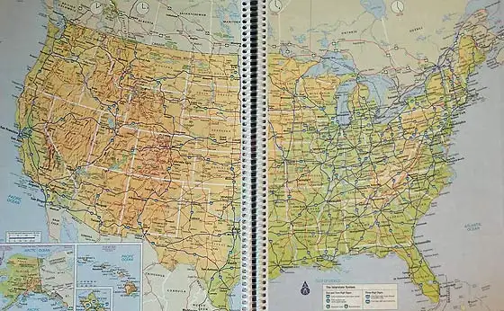
But when you need to travel more extensively, a commercial USA road atlas is a convenient choice. I like the spiral bound USA road atlas for easy page flipping.

You can also get a Road Atlas for a given state. There’s way more detailed information than a folded paper map.

I keep several state road maps / state road atlas maps in my truck. They cover not only my own state, but the various states around me (and one for the entire USA). Theoretically I could travel anywhere in the U.S. without a GPS, without issue.

With all that said, I do use, and appreciate, my own vehicle’s built-in GPS navigation unit. However I have a personal preference for reading quality maps while getting a feel for the terrain or region and its roads. I find that a GPS unit and its relatively small screen size (compared to a road atlas page!) does not provide a large enough perspective. There’s nothing like opening a road atlas (they all have topographical perspective too) and viewing the lay of the land.

I have updated the following list of all 50 state road atlas maps (links below). They are the most up to date based on my research as of this publish date. Most are from DeLorme, some from Benchmark, and USA Atlas by Rand McNally.

Road Atlas Maps (USA & State)

Best USA Road Atlas

spiral bound USA road atlas

I have traveled all across this country, east to west and north to south. Prior to my first big trip, I wanted to get the best road map of the USA. Well, a map would be huge. So, better yet, a road atlas of the USA. After a bit of research, I chose the following. This is their latest update:

Rand McNally Large Scale Road Atlas USA
(view on amzn)

Looking for the latest folding / folded map equivalent? This may be the best road map of USA:

Rand McNally Folded Map
(amzn)

Best Road Atlas For Each State

 
Alabama

Alaska

Arizona

Arkansas

California

Colorado

Connecticut / Rhode Island

Delaware / Maryland

District of Columbia (Washington DC)

Florida

Georgia

Hawaii

Idaho

Illinois

Indiana

Iowa

Kansas

Kentucky

Louisiana

Maine

Maryland / Delaware

Massachusetts

Michigan

Minnesota

Mississippi

Missouri

Montana

Nebraska

Nevada

New Hampshire / Vermont

New Jersey

New Mexico

New York

North Carolina

North Dakota

Ohio

Oklahoma

Oregon

Pennsylvania

Rhode Island / Connecticut

South Carolina

South Dakota

Tennessee

Texas

Utah

Vermont / New Hampshire

Virginia

Washington

West Virginia

Wisconsin

Wyoming

Also of interest, a book called Next Exit. Lists services located at USA Interstate exits nationwide. Gas, food, lodging. shopping and other facilities.

39 Comments

  1. Thank you so much for the links for all the area maps. Like you, I like to look at a map to get a mental image in my head of where I am going, you just can not get that from a GPS. I have so many maps that I can no longer keep them in the glove compartment of the car. I keep them in a file folder in the filing cabinet. I pull out the ones I need before a trip and study them. Our GPS is more of a back-up used to verify that we are still on track. The only one I currently keep in the car is our state. I actually need to replace a few maps as they are about 30 years old. Besides being well worn, I am sure that there are also new roads that just don’t show on the older maps.

  2. A few years ago one of the employees in my daughters company mentioned that each county here in Texas keeps detailed maps of all roads including back country gravel roads. Well, out of curiosity I went on the Internet and made copies of all the county maps between Houston and my ranch (100 miles). I kept these maps in my truck and about a month after making these maps a major hurricane hit Houston. The general Houston area was evacuated and all the freeways, major roads were completely stop and go. It was later shown on TV that it took 10-12 hours to get to San Antonio (180 miles). It took me 1 1/2 hours to get to the ranch using the back road maps. The back roads were empty. The little sheep had all ran to their customary freeways. I will never again travel without those county maps. My guess is that all counties in this country have these maps for general road maintenance. Try your state for these maps. Be safe.

    1. Good advice. Another practice I employ is to use alternate routes when traveling to frequented locations. It may take more time in some cases, but it helps to understand the dynamics of the area and turns otherwise monotonous travel into learning opportunities.

      1. On a side note, it’s important to recon the routes first with the maps Ken discussed or you could have unexpected encounters. About ten years ago we were on a family vacation at Yellowstone and we took a day trip down to Grand Teton. On the way back to our lodge in West Yellowstone in the evening we decided to take a “short cut” over to Idaho so we didn’t have to travel through Yellowstone Park. There was a road on the poor map we had, I’ll call it a tourist map of the area, that cut over to Idaho called Grassy Lake Road, so we decided to take the route. Started out with a nice paved road, turned to a decent gravel road, and when we were into the trip about 30 min it turned into a forest road that more rocks the size of footballs than gravel. We thought it couldn’t be far and it would improve again. Boy were we wrong. After two hours of bouncing over boulders with our Chevy Astro, we were halfway into the trip, parked on the 15 foot wide crown of a levy that contained Grassy Lake Reservoir. We could see in the moonlight the huge reservoir on one side and a 1-200 ft embankment dropping of on the other. It was a beautiful area but I was unprepared for that trip, in the middle of the night with four young kids in the van. We would have been SOL if we had had any trouble at all. After another two hour of boulders, switchbacks, and washouts, were were in Idaho. I would love to go back and see that trip in the daylight but haven’t had the chance. Always had a fond attachment to my Astro after that trip for holding together And getting us throu. Have a good map, it could save your life.

    2. County road maps are EXCELLENT resources. If you can’t find them online, try the County Clerk’s office or county highway dept.

  3. I always keep an atlas and local maps and a compass in the car, but I use my GPS for convenience. Occasionally I play games with the GPS where I’ll put in a destination and not take a single road it suggests to see how long I can do that before I have to take a road it says to. Eventually (the final road) you’ll have to. :D Do I enjoy aggravating technology? Am I obsessed with the word “recalculating”? Not really, but it’s kinda funny when there’s other people in the car!

    I think the best use for a GPS though is the ability to just get lost. Not being sarcastic about the technology, what I mean is just going out for a drive with no destination in mind and just seeing what you see. Eventually you get so lost you turn on the GPS and hit the home button. Which by the way, should not be your address!

  4. No GPS here.
    Delorme maps and the “world’s best copilot” My Wife

    1. Being very nearly IT illiterate, we do prefer DeLorme Gazetteers as well. We also have at least one compass IN each vehicle as well as the ones in our gear or on us personally.

      We’ve found that the majority of people, even in our age group do NOT know how to read a map to save their own hides. Shocking that those folks have such an over-reliance on technology.When I was in law enforcement, I always carried a county map or two, PLUS, a Gazetteer in my patrol bag. Needed it more than once out in BFE.

      1. – TPSnodgrass,
        Agreed on the Gazetteers, and DeLorme is the best one I know of. Just for those who do not know, County maps are available for every county I have ever looked for, online and can be printed (Watch the scale, though) through your own printer and paper.

        Been in BFE, too. Must not have been on the same day, I guess. LOLOL

        – Papa

  5. Great point Ken. As usual, very thought provoking.

    We keep road maps, geopolitical (hunting) maps, topographical maps…of our state and surrounding states.

  6. No GPS here, just great road and topo maps. We also have large US and world wall maps for inquisitive grandkids (mostly the one I homeschool). Personally, I’m a map-geek. :-)

    In our BOBs, we each have topo maps (duplicates) of the entire western Virginia region. Many are online and worth getting. Thanks for the extra links, Ken…worth checking out.

  7. I highly suggest:
    “The Next Exit: The Most Complete Interstate Hwy Guide”

    This is very useful even for non-interstate travel.

    From Amazon’s description:
    “The most complete USA interstate highway exit directory ever printed. Find any service you need in the windshield, not the rear view mirror. Gas, food, lodging and a host of other recognized national and local brands. Updated annually, 512 pages, light weight and easy to use format. No batteries, easily find points of interest 5 or 500 miles ahead.”

  8. AAA members can get free maps and travel guides. If you aren’t a member, ask friends to see if any of them are . I try to get new maps every year or two. Also some State Farm agents will give away a full sized atlas to customers upon request if they stock them. Not all do.

  9. I use the Bureau of Land Management Maps, they are very accurate and updated often. They also show all and I do mean all roads, or as we call them “paths in the dirt”.
    NRP

    1. The Forest Service frequently has maps of national forest lands, roads, etc. too.

  10. My husband and I take weekend, mostly Saturday/Sunday trips.
    I do use GPS some, but even with that, I have my directions written on paper, step by step, and an atlas.
    You are right; there have been times I used all three.

    Especially when we have hours to kill on Sunday and choose the back roads through little towns for fun. You may be surprised what you can find in out of the way communities.

  11. The Gazetteer’s show rr tracks, boat ramps, trails, as well as roads.
    They are great books.

  12. No GPS here. Something about it aggravates me. I keep local maps in the car and state maps in my file cabinet. If they are old, and some are, I get new ones before I travel and plan my trip. I am the only one I know besides my parents who still knows how to read a map.

  13. When I was in Texas I had a chance to help 2 young guys who were lost and their gps just wasn’t cooperating.I pulled out my atlas and helped them.Sad part was they had no clue how to read the map.Had to explain how to figure out the mileage legend.Ended up pulling out a sheet of paper and rough traced their destination with a couple major roads for them to judge how far they still needed to go.The topper was when one of them was concerned I had done something illegal by rough tracing over the atlas map.That conditioned fear has replaced common sense I fear…

  14. I have maps that show Off Highway Vehicle trails, snowmobile trails, and forest service trails. I use these to navigate towards remote lakes, game trails, and berry patches. There is also an interwoven trail system that I can use to my bug out location by foot, if necessary.

  15. I’ve been looking for maps of the railroad systems. Both current and historical type maps. Any ideas or leads I might try?

  16. Just returned from a road trip from NH to FLA…used the GPS the whole way. It worked fine for me, as I had mapped out before hand to avoid large urban areas. I just broke the trip into segments and programed the route I chose that as a series of waypoints…that being said, my wife would have loved to have the atlas to be able to visualize where we were. Also, I have almost always kept a Gazetteer in my rig. Going to order the Atlas, and the most current Gazetteer for my state right now.

  17. As I mentioned before mailed a new Tenn. map to my granddaughter to put in her car. She might only be going to school in Chattanooga, but there are plenty of Blue Highways back home.
    Something I have done that is sort of on the same subject is to find our property on search maps, check the aerial view and print out all of the surrounding homes/property. Looks very different from above and is a good way to ‘know’ things.

  18. – One of the better moment in dealing with GPS came all unintentionally when I was listening to two young lieutenants arguing about where they were and one of them said to the other, and pointed as well, “No, no way. We are on that mountain over there.” That was when I became convinced that the reason the Army sent sergeants along on these expeditions was so someone would be able to rescue young officers when it got beyond hope.

    I can use GPS, Don’t like it, but DW loves it. Still have maps along in the pockets of the backs of the seats, and at least a compass in my bag if not mounted to the windshield.

    – Papa S.

  19. Great article, nothing like a real map. Have had the gps on my phone freeze/shutdown/etc more times than I can count over the years. I’ve also taken the AAA map route, “free” with a membership. I make sure to keep a set of all surrounding states in get home bags in both our vehicles. Not as durable as a real road atlas but if your on a budget it’s a great way to go.

  20. I have the Delorme books for Michigan and Ohio (only areas I travel these days and I don’t do much of that any more) but really I don’t need them that much as my work area is just in my area that I know pretty well.

    I love maps but they are just not that important at this stage of my life.

  21. I bought a large paper and smaller laminated WI road maps a few months ago.
    I have no clue where I put them.
    But, probably in a safe place so I won’t forget.
    Sucks getting old.

    1. Horse, When you find them can you send along that package of washers I can’t find? I put them in the safe place too.

  22. Checked a few links, takes me to maps last updated bestrewn 2010 and 2017.

    1. That’s right. That’s the last apparent date some of them were updated by whomever updates them.

  23. Gene and I loved to visit a state park or historical site a weekend each month.
    He also trucked a few times when logging was not profitable.
    I have those atlases still; I used those on trips. I’d not be without them for anything.

Comments are closed.