Which Coordinates Format for Reporting Location to SAR Emergency Responders
Geographical coordinates formats can be converted from one georeferencing system to another. But I wondered which format might be preferred by SAR (Search And Rescue) operators and/or emergency responders.
In my opinion, any hiker/backpacking/wilderness-traveler, etc.. with a smart phone should have a GPS app, and know how to get their location coordinates.
The other day I had a need to accurately identify True North. I own several descent compasses, and I know the magnetic declination where I live. I knew that I could get pretty close to True North with sighting my compass – which is what I did. However immediately afterwards, my inner tech-geek begged me to play with my iPhone compass and navigation apps. To see how good a job (or not) that I did with the compass.
Given my occasional propensity to get things ‘perfect’, I could see on the app that my established True North position was just slightly off, so I re-tweaked the project. While using the compass app, and also seeing the additional information displayed with my present location coordinates, it reminded me of a curiosity I’ve had…
Is there a particular coordinate system most often used by SAR / emergency responders, SAR operations, forest service, etc..?
Do they prefer to use one coordinate format system over another? If yes, then which one? I would select that one on my app as the default for ‘just in case’.
If one were to become in need of rescue (there are many hypothetical scenarios), a phone app could be used to determine one’s location coordinates that you could relay to search-and-rescue on a call. And again, although they could convert to whatever it is that they use, why not set it to that format to begin with…
Well I found the answer in the “Land Search and Rescue Addendum” to the “National Search and Rescue Supplement” to the “International Aeronautical and Maritime Search and Rescue Manual”, downloaded from the Homeland Security Digital Library.
The answer begins on page 4-44 (source PDF) and is spelled out in the table on page 4-51. Additional online searching reveals the same answer…
Primary Georeferencing System for Land-based SAR / Emergency Responders
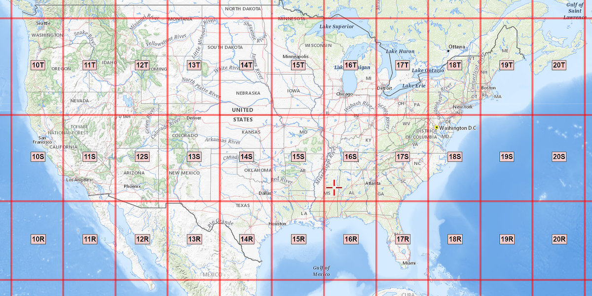
At least in the United States, Land-based SAR responders (apparently) use the UTM numerical grid (Universal Transverse Mercator) map projection system along with the U.S. National Grid standard/format, USNG.
It is a grid-based method of specifying locations on the surface of the Earth. Think of it as a huge grid of 1 meter squares laid over a map of the earth.
Secondary Georeferencing Coordinate System
The secondary coordinate system for emergency responders is Latitude/Longitude DD-MM.mm (Degrees, Decimal Minutes). Note this is the primary georeference system for Aeronautical SAR responders.
Note there are three ways to state latitude/longitude.
- DD.d (Decimal degree)
- DD-MM-SS (Degrees Minutes Seconds)
- DD-MM.mm (Degrees Minutes)
Which format to use while reporting your coordinates to emergency responders?
First of all, use whatever you have! Dispatch or coordinators will figure it out to relay your location to SAR responders in their preferred format. Search teams will likely be using topo maps. They may convert the coordinates to their preferred format, if it differs. There are lots of agencies out there. Just because apparently many of them may use UTM, it doesn’t mean that another may prefer and use latitude/longitude in degrees and decimal minutes… (or any of the three ways to state lat/long.)
While researching this, I read the following comment from a forum discussing this very issue:
“I would recommend UTM coordinates; it avoids the formatting uncertainty of lat/long and is better suited for ground operations. (Easy to translate to paper maps, define search areas, and calculate distances.) If you use the WGS84 datum, the numerical portions are also identical with the military grid reference system (MGRS) and the national grid (USNG).”
If you who are reading this are involved with SAR and/or you are a emergency responder, let us know what your agency uses in the comments below.
GPS App on your phone
Most everyone these days has either an iPhone or Android phone. There are many various apps which include readouts of your coordinates. GPS apps. Compass apps. Navigation apps. And those apps vary with regard to which georeferencing/coordinate system they display.
Some apps have more choices for this in the settings/options. I suggest that either UTM or DD-MM.mm (Latitude/Longitude) would be good choices for a default. I have found that most all related apps will display latitude/longitude (in a variety of several possible formats). The more well known apps include the UTM format too. I’ll let you know what I’m currently using in a minute…
TIP: If you are ever in the situation where you need to report your coordinates to emergency responders, ask the person on the other end to repeat back what you’ve just told them! Getting a digit wrong may wind up far away from your actual location (depending on the digit)!
Examples of UTM coordinates versus DD-MM.mm
It’s beyond the scope of this article to explain how to use UTM or latitude/longitude. There are lots of online resources if you’re interested. With that said, I simply want to show you an example of each.
Lets find a location to reference. Lets use the Washington Monument. This is how the coordinates would be displayed for UTM, and lat/long in the DD-MM.mm format:
(UTM)
18S 323479 4306481
(DD-MM.mm)
38° 53.36904N 77° 2.11674W
My default iPhone compass app displays lat/long. in DD-MM-SS (the format cannot be changed). The neat thing is you can press and hold on that readout, and copy it so you can paste into a text or email, etc..
I also downloaded “Commander Compass”. The free version has lots of cool features, including the ability to switch coordinate formats (including UTM).
I’ve had the Gaia GPS app for some time. It can also display UTM and other formats.
Years ago I purchased a handheld Garmin GPSMAP 64st. It has many built-in options as to how to display your coordinates, including UTM, USNG, etc.. I would use it while out in the backcountry, trails, snowmobiling, etc..
There are lots of related apps! For those who happen across this post, I’m curious about which apps you prefer for this type of thing…
Handheld GPS units
(amzn)
[ Read: Map Basics: How to read Latitude and Longitude ]
Also note that for lat/long the West longitude coordinate is often denoted as a negative value, especially with DD.d as used on goggle maps.
While military and formally trained SAR responders (often certified by NASAR – National Association of Search and Rescue) most law enforcement agencies are often clueless of any grid coordinate system and in the US the county sheriffs office is generally the default agency in charge unless on state or federal land. So… with that in mind one might use lat/long when talking to 911 on a phone.
There are (or were, many of my iphone navigation apps are not supported with later iOS versions) some good phone apps that do coordinate conversations between all the different systems and can calculate distances and bearings between points for the hard to do systems like lat/long.
There are huge swaths of back country where there is 0 cell signal, GPS data on phones relies on that phone being able to talk to a cell tower,
If you are lost or injured out in the boonies you may well be SOL
Not accurate. Most all of today’s cell phones have GPS built in. No cell signal necessary for that.
No.
Ken,
I have multiple gps and navigation apps on my iPhone that work with no cell service. Here are two of my favorites.
MilGPS gives me very accurate location data with no cell service and I generally use MGRS. I have used it in the Alps of France, the backwoods in the midwest, the back country of Arizona. It even works in Airplane Mode and places in between. I have used it to determine where I am while flying commercial with the phone in airplane mode. I have used it a lot over the years and my phone running that app doesn’t do too bad with no cell service when compared to my Garmin eTrex and GPSMAP 65. Horizontal position accuracy (both the app and Garmins tell what that is) on the phone may be double or triple the GPSMAP (it has a far superior antenna) but is pretty much the same or even better than the old bottom end eTrex handheld unit.
Another app I like is Topo Maps. Unlike virtually all apps that plot your position on Google Maps and need a cell data connection to do that (generally a Google license prohibits caching their maps) this app uses USGS maps that you purchase and are loaded and stored locally on your phone. This makes it function much more like the Garmin GPSMAP series of products. So, my phone can give me not just coordinates in about any format with multiple choices for the datum used (NAD27, WGS84, etc.) it can also display position on a topographical map with zero cell service.
So, yes. You are absolutely right Ken.
Bill, Thanks for your input! And for the app recommendations. ‘Topo Maps’ is awesome. MilGPS looks great too – love the big clear indication of coordinates. Also, seemingly one of the perfect phone apps strictly for displaying current position (written by the same who coded the MilGPS app) is a free one titled ‘USNG Me’. Nice!
I’ve also wondered if SAR /emergency-services agencies tend to use military MGRS designations versus straight UTM (both are using USNG, but MGRS includes an additional 2-letter quadrant indication).
Now I’m tempted to purchase MilGPS :=)
(Maps are fun)
The one and only good thing I can remember Bill Clinton doing was when he told the military to switch off SA, (selective availability). Does anyone remember those days? The GPS signal was deliberately degraded to reduce precision to prevent it from being used against us. The military had corrective software to unfark the signal. But then Russia was getting all of their GLONASS assets up and China had plans to do the same so Clinton told them to shut off SA and let the people navigate. —- Still have my Garmin wedge unit from 1995 along with the 8mb $199 Los Angeles map cartridge.
Tmac,
Yes, I remember those days with Selective Availability.
An interesting thing was in addition to GLONASS coming on line, the US DOT and FAA were developing differential GPS systems for aviation that totally bypassed the SA feature that skewed the clocks on the GPS satellites degrading accuracy. They were pursuing this for instrument approach and landing systems with better accuracy than the old analog systems.
Additionally, there were a bunch of commercial systems coming on line providing Differential GPS products for use in business and agriculture that yielded far better accuracy than the US military systems.
It became evident there was little point to keeping SA turned on. I was glad Clinton ordered SA deactivated but doing so was actually in the US best strategic interest, otherwise a lot of reliance would shift to the Russian system which could be shut-off by them at anytime thus quite adversely affecting the US economy and stability if there was too much dependence on it.
Now we have the WAAS system operated through the GPS satellites that drives accuracy better still and commercial DGPS correction data is available through the internet with cell phone data connection that can yield accuracy to less than 6”. The precision ag industry is mostly there now.
Ken,
I went through lots of SAR training 10-12 years ago. Was certified by NASAR as a SAR Tech and went through their Managing the Lost Person Incident. NASAR trained folks to use UTM with the WGS84 grid datum. But as you noted, when you are at a local level the numerical portion related to position within a 100km grid square is all the same between MGRS, UTM and USNG.
I too find all the map and navigation stuff interesting. Here is a fun one for you to research and enjoy. Before GPS there was a global navigation system that was decommissioned in 1997. No, not Loran. It operated on VLF frequencies between 10-14 kHz. Yes kilohertz. You could hear it at the antenna and transmitter. Do you know what it was?
Tmac, Bill…anyone that knows,
I’ve got a Garmin e-trec (I believe that’s correct) I bought back in the days y’all are talking about when accuracy was only about 36 yards (IIRC). Are y’all saying that the old equipment will be more precise now, or does it require new units?
Dennis,
I believe the newer handheld gps units that are WAAS enabled are accurate to 3 meters now, last I looked. Depends on if the accuracy is not messed with by the military in times of alert.
Minerjim,
Thanks. Our forensic mapping GPS equipment (similar, if not identical to land surveying equipment) was supposedly accurate to 6″. While I never used it except in training, I did complete the certification training (only as back-up for those who used it on a regular basis). When it came along, I had the seniority to let others do that tedious task (mapping crime scenes to scale, prior, we used tape measure). Amazing the accuracy from triangulation from satellites that far up.
Dennis
When Selective Availability was active the civilian GPS equipment could provide about 100 meter horizontal accuracy at best and the military stuff was about 10 meter at best as I vaguely recall. I might be off a bit but not by much. When SA was turned off in 1996 then all the civilian GPS equipment essentially could match the military. The Russian system could provide 30m accuracy, hence the interest. That make a difference to a boat trying to find a harbor in the fog. Still not accurate enough for aircraft to land while in the fog/clouds. Hence the deployment of the Wide Area Augmentation System, WAAS.
To understand WAAS and your surveying equipment, they utilize differential GPS, DGPS. There are dozens of DGPS systems now but they all rely upon a common concept. A GPS receiver is parked at a fixed location that it knows very accurately. It listens to the satellites and what position they tell it. The fixed unit compares his known fixed location to the GPS computed location and figures out how far off it is. It then tells other mobile GPS receivers in the area in real time what correction to apply to their GPS determined coordinates to improve the accuracy.
Your survey equipment likely had a base unit you parked somewhere, maybe over a benchmark, and it didn’t move. It then talked over a radio to your portable units and would send them correction factors. These can get accurately in a few inches.
WAAS has stationary receivers around the country that determine the GPS position error and then send correction factors to satellites that relay it to your receiver using the same radio frequencies as the GPS signals. WAAS generally can get you down into the 3-5 meter accuracy plus altitude accuracy is much better too. The FAA deployed WAAS for aircraft to better find runways.
In My Own Words,
Yes, you got the quiz question. Before GPS we had Omega for global navigation. There was yet another system most aircraft used and that was VOR. VOR had full continental coverage whereas Loran was concentrated along coastlines and pretty spotty inland. VOR would not give you position directly, rather gives a vector to a ground transmitter that is marked on your sectional maps (maps specifically for aviation). You would determine a vector to at least 2 transmitters and you could do your own trianglization on the map. Planes could also fly directly towards or away from the VOR station and these formed the invisible victor highways in the sky.
I bought a Bivy Stick after reading an article here on MSB.
Your coordinates are available in the Bivy (smart phone) App.
If I’m in real trouble, that tool will likely by my first choice.
I will likely have secondary and tertiary options also, but nothing says “I’m in trouble and this is where I am” quite like pushing the button on one of the satellite communicators.
Ken, to be clear my point was the individual preference we all have, not my intent to bash your article, but to place your eggs all on electronics as the panacea and if and when a major shtsf hits the fan and electronics are possibly dead or unusable the savior will be yourself and non-electrical supplies. We all better have some “old school learning” and physical items like, maps, compass, warning devices, and common sense to use them.
Realist, Well, I consider it common sense to not put all of ones in eggs in one basket. Should go without saying. The article wasn’t about that. Instead, it’s addressing a single question having to do with modern-times navigational coordinates format systems. Wondering what the SAR community uses most – just because I’m curious and I like maps.
Also, some of you may tend to assume that all articles here are written towards “shtf”. Whereas some are, many also are not (including this one). I’m not ‘shtf’ 24/7.
Ken agree……thanks for your efforts……perception gets scrambled sometimes 🤯
Copy that. Thanks for your input.
Lat/Lon is the worst – when sending and receiving the coordinates are all digits, no clear delineation between degrees, minutes, and seconds. For this location, 42 14′ 18″N 85 38′ 15″W you have to say:
four two degrees one four minutes one eight seconds north; eight five degrees three eight minutes one five seconds west. Look how long that is, just try reading it without getting lost.
I think that USNG is better than UTM. Fewer digits and letters are used for 100k grids. Those 100k grid square letters can be sent as phonetics. Suppose you want to provide 8 digit coordinates:
16T FM 1241 7713 versus 16T 061241 467713
one six tango foxtrot mike one two four one east seven seven one three north.
or
one six tango zero six one two four one east four six seven seven one three north.
It seems to me that two 6-character long digit strings are harder to read and send and harder to receive and write down.
Regarding eight digit versus ten digit – if they can get within 10 meters and can’t find you they need to turn in their compass.
Your advice to use what you have is spot-on. Responders (rarely dispatchers) will figure it out … if intelligible coordinates were provided, copied, and subsequently communicated in the first place. The problem is most people don’t know a coordinate system from Adam.
I taught three systems: UTM, geographic coordinate system (GCS – lat/long), and the Public Lands Survey System (PLSS). PLSS is particularly useful out West where so much SAR is conducted on public lands and PLSS is useful with government maps for coarse description of location. UTM is most intuitive and useful for ground navigation and description of search areas. GCS has been inescapable, particularly in communicating with aircraft. I’ve never seen degrees/decimal-minutes used. Decimal degrees is simplest and most intuitive with GCS, as much as lat/long is either.
-30 year SAR incident commander, Fundamentals of SAR instructor, and land navigation trainer