contour lines thick and thin

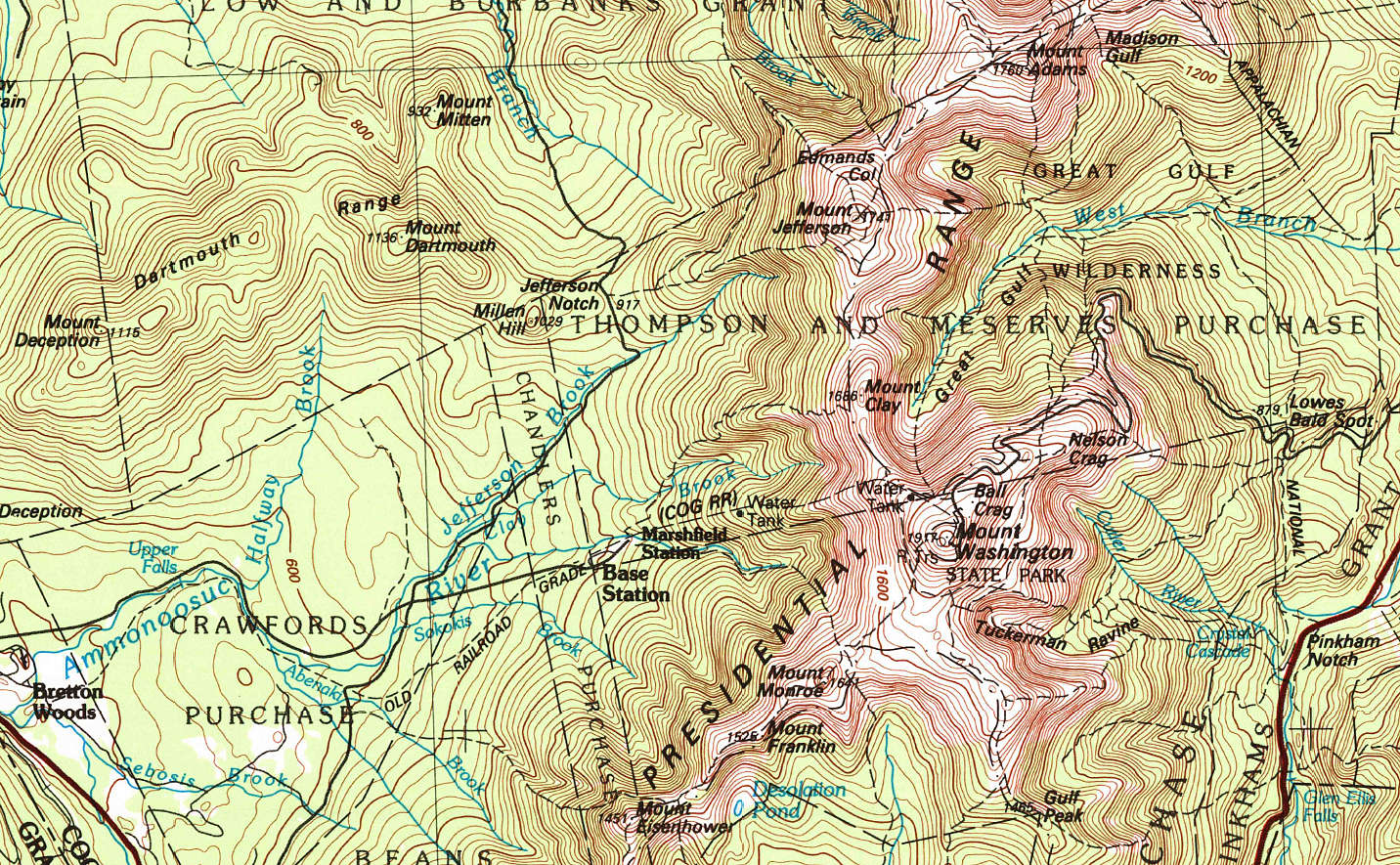
Contour Lines On A Topographic Map

A topographic map is a two-dimensional representation of the three-dimensional surface of the land. A topographic map enables you to visualize the hills and valleys of the land itself. It also provides specific details as to the elevation of the surface. Topography is the shape of the land surface. Topographic map contour lines represent the land surface.

Contour Lines

Lines snake their way around a topographic map. They are called contour lines.

All points along the same contour line are at the same elevation above sea level.

Think of a contour line as a closed loop. By following one, you would travel flat, not uphill or downhill, and would eventually end up back around at your starting point if you went all the way around it. They are used to determine elevations (referred to in feet or meters, above sea level).

Topographic contour lines allow you to figure out general terrain characteristics from their patterns. For example, lines that are crowded close together – means that the terrain is steep. Lines spaced widely apart indicate more gentle slopes.

They also trend up valleys and form a “V” or a “U” where they cross a stream.

Thick and Thin

You’ll notice both thin and thick contour lines on a topographic map. “Index lines” are thick. “Interval lines” are thin. They both represent contour elevation.

Index Lines

However, index lines (the bold / thick lines) are typically labeled with a number indicating the elevation for that particular line.

Interval Lines and Contour Interval

The thin interval lines are unmarked.

The distance represented between each of the interval lines is known as the contour interval. The contour interval is stated on every topographic map and is usually located near the scale.

For example, if a topographic map scale indicates a contour interval of 6 meters (nearly 20 feet), and a particular thick ‘index’ contour line on the map is labeled ‘1040’, this means that everything along that contour line is at 1040 meters elevation above sea level (the newer USGS topo maps are in meters), and each thin line above or below that index line is a difference of 6 meters.

Note: A thought to bear in mind when you are using a map out on the ground… The gap between the interval lines – 6m – if a feature on the land is smaller than that height, and situated between two elevation intervals, it may not appear on the map at all. So, be aware of that distance, depending on the map you’re reading.

Topographical Map Contour Lines Visualize The Land

The beauty of a topographic map is its ability to infer a picture in your mind of the lay of the land. Once you allow your eyes to observe the overall pattern of the thick and thin contour lines, it becomes fairly easy to imagine the hills and valleys.

The topo map may help you locate where you are. For example, if you know that you are within the confines of a given map, you could potentially look around and identify several (3 is good) points such as hilltops, valleys, etc. and then look at your map with that frame of reference in your mind while searching for the same identifiers on the contour of the map itself. By using triangulation you could discover your current position on the map.

The unique “V” or “U” shapes along lines of contour will indicate where rivers and streams will likely be (which themselves are typically drawn on the map in blue).

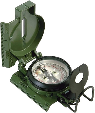
Of course it would help to have a good compass!

Here’s a quality classic, Made in the USA. I’ve had this one for many, many years. The tritium still puts out light…

Tritium Lensatic Compass
(view on amzn)

There are countless uses for topographic maps. It may be a good idea to have several which cover the geography of the land near where you live, or other areas of interest where you may travel.

The USGS site, store.usgs.gov is a nice resource where you can select a location for available map options. You can download them as a PDF for free. You can also purchase hard copies too.

[ Read: Compass For Map Reading And Navigation ]

17 Comments

  1. Learning a how to read and mentally visual a topo map will not only help ensure you get to your destination but is necessary to plan and choose the shortest, safest, easiest, quietest or most advantageous route depending on your physical abilities, gear and reason for the trek. The shortest distance between two points may be a straight line but if it includes climbing mountains, crossing rivers, descending into gorges with cliffs it might not be the best route. Planning and being able to implement a plan that is within the level your skills, gear and abilities are crucial to a safe and successful trek in the wild.

  2. Double Tap,
    Ken has done it again. He has provided your answer for the ham question. Might be a different/shorter way to contact your friend?????

    I too have topo maps. I’ve gotten a little lazy with gps and all. Built a nice frame and put one behind glass of my area. Even if ya know the area well, it gives a different perspective. Thanks Ken!

  3. thanks ken,
    everyone needs these. a good TOPO map is a great resource map. elevations,springs and pond’s. old homesteads that may have wells ‘they don’t update these maps very often’ . they don’t cost much and they are easily available through the gov website. there is only 5 offices in the country and one is 50 miles north of me! been there a few times.

  4. I don’t know if they still sell them but I have aviation charts (WAC world aviation charts) for at least 1000 miles around my AO. They’re not informative as the more detailed topo maps but are just like topo maps for details such as spot heights, general contours, rivers, water and urban areas. They give a broad perspective and are printed on both sides. A few of the WAC charts take up less space than most road atlases.

    1. Jack Frost,
      i had not thought of those for years, but they would be great to have if they are still available.
      you can’t have To much information.
      good luck friend

  5. I was fortunate to have the dad I had. As a youngster he got me interested in looking at maps and using them properly. All kinds of maps. I used topos throughout my career in natural resources and they are still my hands down first choice.

  6. So many people rely on their phones and GPS and they can’t imagine life without them. There will be no way to google “how to read a map” when the grid goes down or the satellites are knocked out. If you don’t understand basic map reading and land navigation now, it will be difficult and may have a possibly dangerous learning curve in the future.

    Most people are familiar with their surroundings using marked roads and highways but have no idea what is on the other side of the trees along these roads, where a natural water source or a hazard may be. Know where large power lines and railroad tracks run as these are kept clear of trees, are normally easily to walk and are a known connection to other towns.

    Learning to read a map of your AO will no only teach you basic navigation but will allow you to see things on the map that you never knew was there. Prior knowledge, skills and information is PRICELESS when you are in a situation where your access to it has been cut off.

    1. SS,
      Good advice and thanks for the info on the Pentel 8 pen. Sounds like a good system and I’ll order some.

  7. Nyscout
    They seem to have stopped producing the WAC charts for the US in 2015 but they may have been replaced by high altitude planning charts, there is an index on the supplied link, as well as area specific low altitude planning charts. They’re free and downloadable as compressed PDF or Tif files your tax dollars have already paid for them lol!

    Good hunting , useful to print in part or add to your thumb drive in your BOB.

    https://www.faa.gov/air_traffic/flight_info/aeronav/digital_products/ifr/

  8. During my travels in Central and South America, I took maps of North & South American countries to show the locals. I was amazed at how few people had even seen a map before, and could not relate to it at all.
    They would just blankly stare at a map, completely befuddled. Had no idea what the world looked like.
    How sad, the education systems were.

    1. Backpacker, “Had no idea what the world looked like” my wife is in the same situation, she was never taught/shown how to read a map when she was growing up. I try/tried to teach her (using road maps to start) how but, she still doesn’t get it. She still is confused with north/south, east/west direction/orientation. Will keep trying thou.

      1. The country she grew up in, the only places that flew the countries flag were government buildings, the people did not fly the flag at home or at work.
        When she came here, she was surprised at all of the U.S. flags being flown by people. She even asked me if it was a requirement (by the government) to fly the flag at your residence/house. I told her no, the people are just proud of this country and the flag that stands for it.

  9. Even if you do not live near a USGS office, these maps can be obtained from sister agencies such as USFS, USNPS, Bureau of Land Management ( the other BLM prior to the riots of 2020 ). If there is no Federal office or agency near you, you can get your start by going to the county seat and contacting the hall of records where the land deeds are kept. From there, one can obtain more info about more detailed maps.
    As stated before: The few perks of working for the Feds was observing some of the networking that goes on when it is important to obtain information. ( ie. Maps of an area that is burning )

  10. Things not to be found on a topo map: The importance of pre-season scouting or another excuse to walk in the woods. When hiking around the hills and through the forest, I pay attention to what kind of trees are nearby and where beneficial trees are located. It may not affect me now but it helps in the future. An example of this is the presence of white oaks in an area that has predominently live oaks and black oak trees. Of all the oak species, the white oak has the lowest amount of tannin in the acorns and result is being the “sweetest acorns in the forest”. This becomes important during hunting season for both deer and squirrels as the land around the white oak tree will become a magnet for animal activity. I have observed the same tendency around a pinon pine tree within a forest full of other conifers. These trees are rare treasures and if you find one in your area, I try to encourage growth and promote seedlings because so many creatures prefer these trees for food and shelter.

    1. Calirefugee,
      i have a few topo maps of my area. i have features like abandoned homesteads, water and any kind of fruit trees or wild edibles highlighted in different colors.
      on blueprints you would call it a schedule.

  11. – Very familiar with People who get lost easily. My grandmother could easily point out North, South, East, etc. as long as she was outside; take her indoors, and her sense of where directions were was out 180 degrees. Mom wasn’t much better.

    I spent a lot of time with maps while in the Army. Compasses and protractors are just as familiar as the furniture in the living room. I thought I might repeat a couple of things I learned and have mentioned elsewhere on this site.

    When you are laying out a map route, and trying to estimate time and distance for planning purposes: assuming normal undergrowth and decent weather, if you can lay out a straight line on a fifteen-minute map (that’s a 1:50,000 or 1:62,500 map) you can travel the width of your thumb on the map in about fifteen minutes if you don’t cross any contour lines.

    If you cross a contour line, it doesn’t really matter if you are going up or down, add five minutes to your time. (You won’t find this “rule of thumb” very many places.) These numbers are for a general estimation only: your actual time may vary according to weather and other factors. Even a cloudy day may add time to a sunny weather estimate; the worse the weather, the more time will be added. Ditto for heavier vegetation.

    It is possible to find rolls of clear acetate. If you cut sheets of this to fit your map, you can add all kinds of information, especially if you use multiple sheets of acetate to make your overlays. Bedding areas, forage areas, travel routes/lanes, etc. It really makes a map far more useful. You can also mark areas of difficult travel, fences, and whatever else you might want to remember when you are not in the field.

    – Papa S.

    1. – Forgot to mention, alcohol pens are nice for overlays. You can erase them with a cloth dipped in rubbing alcohol to change information if needed.
      – Papa

Comments are closed.