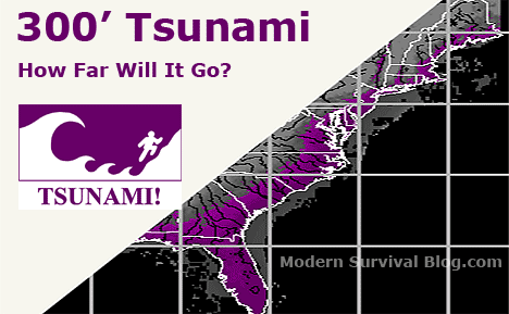
How Far Inland Can A Tsunami Travel On The East Coast USA?
How far inland can a tsunami travel? That’s a question you may be wondering, especially if you live near the coast. Read through all the caveats that I discuss below, before checking out the maps. There’s not one answer. Rather, there are lots of “it depends”.
EAST COAST TERRAIN ELEVATION MAPS SHOWN BELOW
Awhile ago I wrote an article titled “300 Foot Tsunami And East Coast Destruction” (linked below) regarding the possibility of ‘La Palma’ or ‘El Hierro’ of the Canary Islands partially collapsing into the Eastern Atlantic following a major volcanic eruption there.
This event would likely lead to a mega tsunami that travels across the Atlantic and devastates the East Coast of the United States.
Opinions vary regarding the height of the tsunami and range from 60 feet, to 300 feet, and even higher than that as it rolls up the shoreline of the East Coast of the United States and elsewhere.
Canary Islands – La Palma – Cumbre Vieja Mega-Tsunami?
UPDATE: I first published this article during 2013. Eight years later, 2021, a swarm of earthquakes are rattling the Canary Islands – sparking fears of a volcanic eruption. I recalled posting the following East Coast Terrain Elevation Maps with intent of providing some context for a “what if” scenario of a mega-tsunami. Like a tsunami initiated from a major submarine landslide at the Canary Islands, for example.
There have been fears an eruption could cause a mega-tsunami. Steven Ward first explained this theory in research from the Institute of Geophysics and Planetary Physics, University of California, Santa Cruz, California, two decades ago.
image via ZeroHedge via StanDeyo
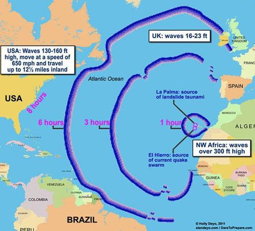
image source: Cumbre Vieja Volcano — Potential collapse and tsunami at La Palma, Canary Islands, Steven N. Ward.
(height in meters)

Evolution of the La Palma landslide tsunami from 2 minutes (upper left) to 9 hours (lower right).
Red and blue contours cover elevated and depressed regions of the ocean respectively and the yellow dots and numbers sample the wave height, positive or negative, in meters. Note the strong influence of dispersion in spreading out an original impulse into a long series of waves of decreasing wavelength. See also that the peak amplitudes generally do not coincide with the first wave.
Even after crossing the Atlantic, a lateral collapse of Cumbre Vieja volcano could impose a great sequence of waves of 10-25 meters height on the shores of the Americas. (research by Steven N. Ward).
(Cumbre Vieja is a volcanic ridge on the volcanic ocean island of La Palma in the Canary Islands.)
Okay, back to the original post. I must have had too much time on my hands back then… plotting several east coast elevation maps:
How Far Inland Can A Tsunami Go?
“IF” a 300 foot tsunami reached the East Coast, how far inland would it go?
Logically one might reason that the tsunami will travel inland until the elevation of the land is higher than the tsunami. While that sounds logical, there are variables…
Actually, the distance a tsunami will travel inland has more to do with the energy remaining as it hits the shore.
A tsunami will speed across the ocean at hundreds of miles an hour but at a relatively small height (because the ocean is DEEP).
It’s speed decreases as it approaches the shoreline (because the ground beneath it is getting shallower) but it’s energy begins to transfer to its monstrous HEIGHT.
When the speed of the wave approaches zero, the wave breaks, much of its energy is released, and it will not go too much further. A tsunami that reaches a height of 300 feet when it rears up at the shore (or any height), will lose energy as it travels inland.
It’s all about energy. Frequency (depending on the source of the tsunami) and Amplitude (shape of ocean floor, shoreline and up-slope factors).
It is conceivable that a given tsunami may rear up quickly (and very high) once it reaches the shore (depending on the shape of the ocean floor leading to the shore), and then ‘break’ and lose much of it’s energy in a relatively short distance. While another tsunami may be more compressed (in frequency) and be thrust forward very quickly while traveling a long distance inland (remember Japan?).
There are scientifically sound reasons for concern that at some point in time a mega tsunami could engulf the entire East Coast with a wave approximating 300 feet in height and sweep everything and everybody inland. The consequences of such an event are nearly unimaginable.
Tsunami Maps (East Coast Terrain)
Out of curiosity and an interest in maps, I have custom built the following elevation maps based on high resolution data from USGS digital elevation maps of the United States, particularly the East Coast. I have modeled several layers of elevation of the East Coast to illustrate various height scenarios of tsunami versus geography as it travels inland.
Having said that, there are many variables and factors affecting how far a tsunami would travel inland. So if you live 20 miles inland along the Florida coast (for example) at an elevation of 50 feet doesn’t necessarily mean that a 300 foot tsunami (at the shore) will have enough remaining energy to travel all the way to your location.
There are some instances whereby such a tsunami would probably only travel several miles inland while there are other scenarios where it may roar up a river way or bay and devastate far inland.
Regardless of the factors, I felt that you may be curious to see following elevation graphics that I layered together which increment 75 feet all the way to 300 feet in height along the U.S. East Coast. I would guesstimate that if you live within 20 miles of the coast, you may be vulnerable to a Canary Island ‘event’. However this is simply my own estimation.
Which American Cities Might Be Devastated by an East Coast Mega-Tsunami?
Several observations regarding a 300 foot tsunami would be the probable devastation of the following major East Coast cities… Even a 75 foot tsunami !
CITY, (Current elevation above sea level, feet)
Portland, ME (~ 50′)
Boston, MA (~ 30′)
New Haven, CT (~ 50′)
Bridgeport, CT (~ 40′)
New York City, NY (~ 20′)
Jersey City, NJ (~ 30′)
Newark, NJ (~ 50′)
Atlantic City, NJ (~ 10′)
Wilmington, DE (~ 80′)
Philadelphia, PA (~ 40′)
Virginia Beach, VA (~ 10′)
Wilmington, NC (~ 20′)
Myrtle Beach, SC (~ 20′)
Charleston, SC (~ 10′)
Savannah, GA (~ 10′)
Daytona Beach, FL (less than 10′)
West Palm Beach, FL (less than 10′)
Fort Lauderdale, FL (less than 10′)
Miami, FL (less than 10′)
There are countless cities and towns in between these coastal cities. The Eastern Seaboard of the United States includes some of the largest metropolitan areas in the country. Over one third of the country (more than 100 million people) live along the East Coast. Evacuation would be virtually impossible for most (except for the astute who act quickly) due to only hours notice, probable doubt, and the subsequent immediate gridlock that would follow.
GET AUTOMATICALLY NOTIFIED IF A TSUNAMI IS COMING
NOAA ALERT RADIO
(view on amzn)
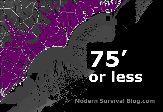
ELEVATION MAPS
THE MAPS BELOW SIMPLY SHOW ELEVATION.
NOT the expected distance a 300 foot tsunami (or any height) would actually travel. With that said, the maps simply provide visualization and reference in this regard.
NOTE: An evacuation plan should include:
Road Atlas Map For Each State
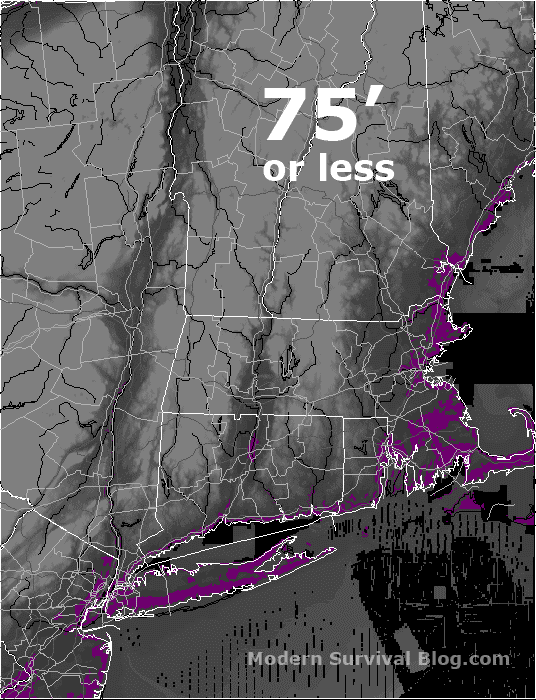
Maine, New Hampshire, Massachusetts, Connecticut, New York Coastal Elevation Map
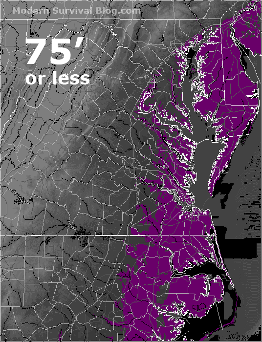
Chesapeake Bay & North Carolina Coastal Elevation Map
North and South Carolina Coastal Elevation Map
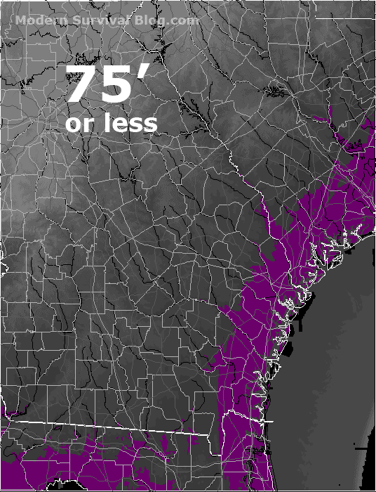
Georgia Coastal Elevation Map

Florida Coastal Elevation Map
Florida with its very low elevation would have particular problems with a tsunami moving in many miles inland!
Reviewer says, “Probably the best book on the topic ever written” :
Full-Rip 9.0: The Next Big Earthquake in the Pacific Northwest
(view on amzn)
